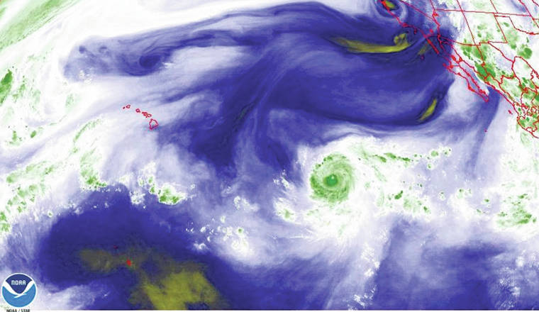
LIHU‘E — The National Weather Service in Honolulu predicted that Hurricane Douglas could impact the island of Kaua’i this weekend.
Douglas was upgraded from a tropical storm to a hurricane Monday night, traveling 2,000 miles Southeast of Kaua‘i, and moving westward at 16 MPH from the epicenter in the middle of the Eastern Pacific ocean.
NWS-Honolulu Hurricane Expert Derek Wroe stated the hurricane would continue to build before the end of the week.
“Right now, the forecast continues to intensify, and looks to strengthen or weaken over the next couple of days,” Wroe said.
According to AccuWeather.com, forecasters expect Douglas to move directly across Hawai‘i, but they call for the storm to weaken significantly by the time it’s projected to arrive late Sunday into Monday, meaning it would spare Hawai‘i the worst impact.
At this time, Wroe said they couldn’t pinpoint the specific trajectory of Douglas’s path because it could change over the next few days, but urged residents to take precautionary measures.
The chance of precipitation is forecast to remain high Saturday, Sunday and Monday. The forecast calls for a 70 percent chance on Saturday and Sunday, and increases to 80 percent chance for Monday.
“It’s hard to pin down the intensity numbers,” Wroe said. “The safest thing we can do is to plan for a hurricane to happen over the weekend.”
Douglas will become the first hurricane of the 2020 Eastern Pacific hurricane season.
It tied the fourth latest date of the Eastern Pacific season’s first hurricane on record.
Douglas could have a significant impact on surf levels in Kaua’i this weekend, Wroe said. As of Wednesday afternoon, Kaua‘i’s highest surf levels recorded were two to five feet with poor visibility.
As Douglas moves closer to the Central Pacific, the surf levels could rise to high levels as early as Saturday. The surf levels will be impacted somewhere in the state, but it was hard to predict as of Wednesday afternoon.
Wroe did state that somewhere in the state, the surf could exceed the warning levels of 15 feet.
“You might not see the surf impact for quite some time,” Wroe said. “It will depend on the exact track. If the storm continues to move in the same general direction, there will be slight changes in the track.”
A recent news release from the AccuWeather Global Weather Center said hurricanes hit Hawai‘i less frequently because of where the islands are located in the Pacific Ocean.
Because of the powerful feature that looms in the atmosphere northeast of the state, storms as large as hurricanes are usually deflected or weakened by the time they reach the region. The temperature of the waters play a role in weakening tropical systems that track through the area.
“Sea-surface temperature tends to run too cool to the east of the islands,” AccuWeather.com Hurricane Expert Dan Kottlowski said. “So, any hurricanes approaching from the east tend to weaken and fall apart before reaching the islands.”
Hurricane preparations
Hurricane season runs from June 1 – Nov. 30 in the Central Pacific. American Red Cross suggests preparing for natural disasters before they strike with three easy steps: Get a Kit, Make a Plan, and Be Informed. Steps to prepare include:
• Know the hazards where you live, work, and play
• Sign up for weather alerts to stay up to date
• Develop an emergency plan with your family
• Build a 14-day emergency supply kit, this year including masks and hand sanitizer
• Consider hurricane or flood insurance if you’re in a high-risk area
• Consider structural mitigation like hurricane clips or shutters
•••
Jason Blasco, sports reporter, can be reached at 245-0437 or jblasco@thegardenisland.com.


