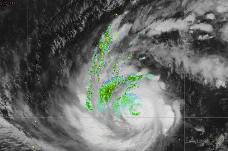
Shelters fill in Guam as U.S. territory braces for Typhoon
HONOLULU — Authorities in Guam warned anyone not living in a fully concrete house to head to safety elsewhere and emergency shelters began to fill as residents braced for Typhoon Mawar, a powerful storm that could deliver the biggest hit in two decades to the U.S. territory in the Pacific.
Gov. Lou Leon Guerrero urged residents in a YouTube message to remain calm and prepare for Mawar, which the weather service said could hit the southern part of Guam around midday Wednesday. She ordered the National Guard to help those in low-lying areas evacuate ahead of the storm as residents stocked up on jugs of water and generators.
“Current forecasts are not favorable to our island,” she said. “We are at the crosshairs of Typhoon Mawar. Take action now, stay calm, stay informed and stay safe.”
If Guam doesn’t take a direct hit, it will be very close, said Patrick Doll, the lead meteorologist for the National Weather Service in Tiyan, Guam.
The center of the Category 3 storm was about 195 miles (313.8 kilometers) southeast of Guam on Tuesday, and moving northwest at 9 to 10 mph (14.4 to 16 kph) toward Guam, according to the weather service.
It was expected to arrive as a 140 mph (225 kph) Category 4 typhoon, weather officials said. Winds could reach up to 150 mph (241 kph), Guerrero said in her video message.
The typhoon could cause “extensive damage,” Doll told The Associated Press.
The governor said she would place Guam essentially in a lockdown effective 1 p.m. Tuesday and those in low-lying areas needed to leave by 6 p.m. Tuesday.
Rain from the storm’s outer bands was falling Tuesday..
A storm surge of 6 to 10 feet ( 1.82 to 3 meters) above the normal high tide was expected and could reach up to 15 feet (4.6 meters). Surf was expected to build sharply in the next day or two along south- and east-facing reefs, with dangerous surf of 20 to 25 feet (6 to 7.6 meters) Tuesday afternoon into Wednesday, the weather service said.
At the island’s grocery and hardware stores Monday, people were leaving with shopping carts full of canned goods, cases of water and generators, the Pacific Daily News reported.
The Rev. Francis X. Hezel, a Jesuit priest and assistant pastor at Santa Barbara Church in Dededo, was trying to visit people at the hospital before it closed to visitors Tuesday.
Before hitting the road, he said he had trouble finding someone to help him put air in his tires because everyone was busy readying their homes to withstand the storm.
“I live in a rectory,” he said. “I’m just closing the windows hoping that the gusts don’t bash them in. Praying for the best, I guess.”
Officials warned residents who aren’t in fully concrete structures to consider moving for safety. Many homes are made of wood and tin.
“The triple threat of cat 4 typhoon force winds, torrential rains and life-threatening storm surge are all expected for Guam and Rota,” the weather service said in a Tuesday morning update.
Rota, an island in the U.S. Commonwealth of the Northern Mariana Islands, was also under a typhoon warning, Doll said. Tinian and Saipan, in the northern Marianas, were under tropical storm warnings.
Some people in those areas are still in temporary shelters or tents after Category 5 Super Typhoon Yutu in 2018, Doll noted.
“Guam takes a Category 4 or 5 hit every five to seven years. Mother Nature has spared us as of late,” Doll said, adding that the last direct hit was in 2002. “So we are way overdue.”


