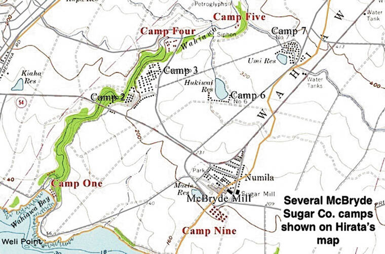
Gerald Hirata, historian, and caretaker of the Hanapepe Soto Zen Temple, has created, for the first time, a revised USGS topographical map on which the names of 26 now almost entirely nonexistent south and westside Kaua‘i sugar plantation housing camps are matched with their locations.
Camps shown on the map were in existence from as early as 1911.
The sugar plantations on which these camps were located are the Hawaiian Sugar Co. (1889-1941), Olokele Sugar Co. (1941-94), Gay &Robinson Sugar Co. (1889-2009), and McBryde Sugar Co. (1899-1996).
Hawaiian Sugar Co., Olokele Sugar Co. and Gay &Robinson sugar lands extended from the Waimea River to Hanapepe, and the camps of these plantations noted on Hirata’s map are Camp 1, Camp 2, Camp 3, Camp 4, Camp 5, Camp 6, Camp 7, Camp 8, Camp 9, Camp 10, Pakala Village and Kaumakani Village.
Of these, only Camp 6 (Kaawanui Village), Pakala Village and Kaumakani Village still exist.
The McBryde Sugar Co. (1899-1996) sugar lands shown on the map extended from Hanapepe to Lawa‘i, and McBryde camps noted on Hirata’s map are Camp 1, Camp 2 &Camp 3 (Wahiawa Camp ), Camp 4, Camp 5, Camp 6, Camp 7, Camp 8, Camp 9 (Numila), Camp 10, Camp 11, Camp 12, Camp 17, and Camp 18 (Kukuiula), none of which now exist.
Missing from Hirata’s map are McBryde camps 13 through 16, which were tiny settlements once located alongside reservoirs in Lawa‘i.
Fortunately, however, in 1979, the bell tower of the Buddhist temple built at Wahiawa Camp in 1918 was replicated at the Hanapepe Soto Zen Temple, which was constructed in 1978.
Born on Kaua‘i, Gerald Hirata is the son of Sadao “Dickie” Hirata and Fumiko “Flora” Hirata, and was raised in his parents’ plantation house No. 14 in McBryde Camp 2.
In 1969, his parents moved to Numila Camp house No. 117.
Gerald Hirata’s grandfather, Yukutaro Hirata, and grandmother, Teru Inouye Hirata, were among the first people to reside in Wahiawa Camp, which was built in 1899, and both his grandfather and father were employees of McBryde Sugar Co.


