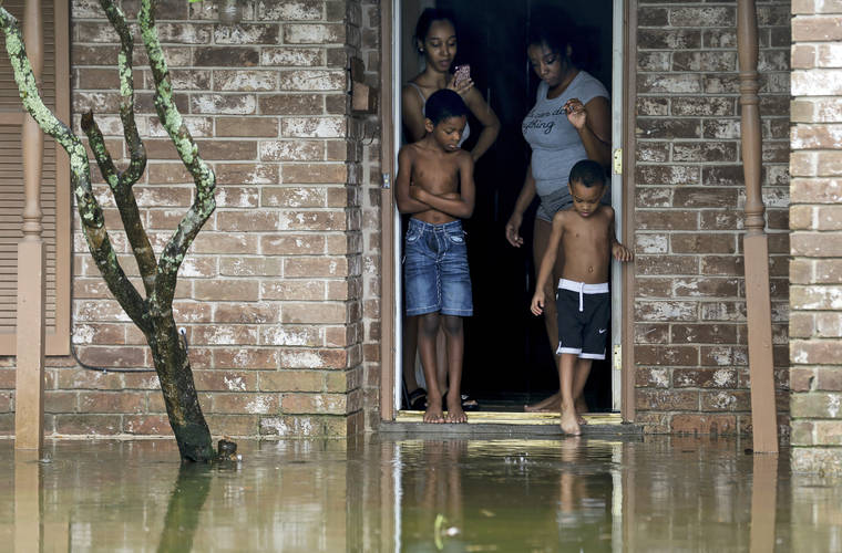
HOUSTON — Beta weakened to a tropical depression Tuesday as it parked itself over the Texas coast, raising concerns of extensive flooding in Houston and areas farther inland.
Beta, which made landfall late Monday as a tropical storm just north of Port O’Connor, is the first storm named for a Greek letter to make landfall in the continental United States. Forecasters ran out of traditional storm names last week, forcing the use of the Greek alphabet for only the second time since the 1950s.
By Tuesday afternoon, Beta was 40 miles (64 kilometers) north of Port O’Connor, Texas, with maximum sustained winds of 30 mph (48 kph), the U.S. National Hurricane Center said. The storm was moving east-northeast at 5 mph (8 kilometers) and was expected to crawl inland along the coast over Texas through Wednesday.
The National Hurricane Center said parts of the Houston area had seen up to 14 inches (36 centimeters) of rain by Tuesday afternoon. One area in Brazoria County, located south of Houston along the coast, got nearly 18 inches (46 centimeters) of rain in the last two days.
Street flooding was reported in parts of the Houston area. Fire Chief Samuel Peña said first responders had done nearly 100 water rescues on city roadways since Monday evening.
Harris County Judge Lina Hidalgo said there were preliminary reports of some home flooding along a creek south of Houston.
Both Hidalgo, the top elected official in Harris County, and Houston Mayor Sylvester Turner urged residents to stay home and off the roads. About 70 barricades had been placed throughout the city in high water areas.
“Your sedan is not a submarine. Your minivan is not magical. So stay off the roads right now,” Hidalgo said. “Your destination is not worth your life. It’s not worth the life of the first responder that’s going to have to come and rescue you if you drive into high water and are stuck there.”
Houston-area officials worried additional rainfall Tuesday evening and Wednesday on already saturated ground and waterways could result in more flooding.
Houston resident Adam Matter, who was out near a flooded downtown area bayou on Tuesday, said Beta’s flooding was “serious in spots. You should avoid those spots, but I don’t think it’s anything to be too concerned about.”
Beta was the ninth named storm that made landfall in the continental U.S. this year. That tied a record set in 1916, according to Colorado State University hurricane researcher Phil Klotzbach.
Beta was expected to move over Louisiana, Arkansas and Mississippi later in the week, bringing the risk of flash flooding.
However, forecasters and officials reassured residents that Beta was not expected to be another Hurricane Harvey or Tropical Storm Imelda. Harvey in 2017 dumped more than 50 inches (127 centimeters) of rain on Houston, causing $125 billion in damage in Texas. Imelda, which hit Southeast Texas last year, was one of the wettest cyclones on record.
Gov. Greg Abbott issued a disaster declaration for 29 Texas counties on Monday, ahead of Beta’s arrival.
Beta was forecast to dump heavy rain on the southwestern corner of Louisiana three weeks after the same area got pounded by Hurricane Laura. The rainfall and storm surge prompted Louisiana Gov. John Bel Edwards to declare a state of emergency.
Parts of the Alabama coast and Florida Panhandle were still reeling from Hurricane Sally, which roared ashore Sept. 16, causing at least two deaths.
Meanwhile, Hurricane Teddy was moving toward Canada, with a predicted landfall in Nova Scotia early Wednesday before heading into Newfoundland on Wednesday night, forecasters said. The large and powerful storm was causing dangerous rip currents along the U.S. East Coast, the hurricane center said.
Teddy was about 300 miles (480 kilometers) south of Halifax, Nova Scotia, on Tuesday afternoon with maximum sustained winds of 100 mph (160 kph). It was expected to weaken through Wednesday, but forecasters said it would likely be a strong, post-tropical cyclone when it moves in and over Nova Scotia.
Paulette, which made landfall last week in Bermuda as a hurricane, regenerated near the Azores but was weakening Tuesday, the hurricane center said. Now a tropical storm, Paulette was expected to become a post-tropical remnant low in the next day or so.
The National Weather Service said on Twitter: “Because 2020, we now have Zombie Tropical Storms. Welcome back to the land of the living, Tropical Storm Paulette.”
———
Associated Press video journalist John Mone in Houston, reporters Seth Borenstein in Kensington, Maryland, Janet McConnaughey in New Orleans and Julie Walker in New York City contributed to this report.
———
Follow Juan A. Lozano on Twitter: https://twitter.com/juanlozano70


