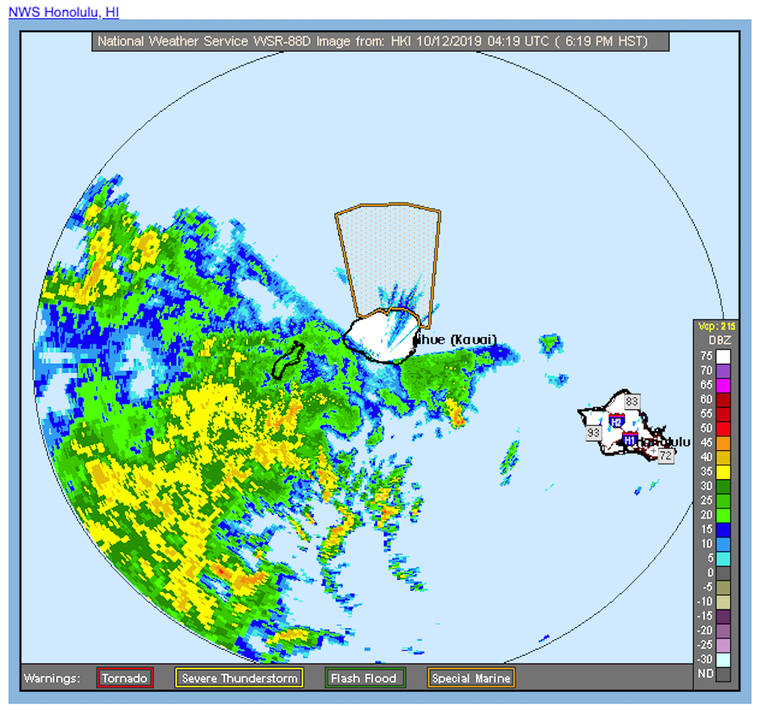
LIHUE — Torrential rains on Friday prompted flash-flood warnings, forced road closures and caused power outages across the island.
A low-pressure system hung over Hawaii most of this week, allowing clouds to accumulate massive amounts of moisture that fell in sheets of rain around most of Kauai starting Friday afternoon.
The National Weather Service issued an islandwide flash-flood warning at 3:30 p.m., about an hour after the heavy rains began.
Shortly after 5 p.m., the Kauai Emergency Management Agency reported water rising rapidly near Hanalei River bridge, with water starting to flow onto Kuhio Highway. Minutes later, Kauai County officials closed the road in the area and volunteers opened Hanalei School as an American Red Cross emergency shelter.
Rainfall rates had started to decrease in most areas, with the heaviest rainfall moving north of the island, according to an NWS warning issued around 5 p.m., which noted that “runoff levels will remain high for a few hours.”
According to U.S. Geological Survey data the Hanalei River rose above NWS flood-alert levels around 4 p.m. and peaked at just over 12 feet shortly after, when, for a brief period, the river discharged about 17,000 cubic feet of water per second, roughly 10 times the average flow.
Kauai Island Utility Cooperative reported localized power outages in Kokee, Kilauea, Lihue and Wailua Homesteads due to the severe weather.
At 6:15 p.m. Friday, an NWS update said the flash-flood warning would stay in effect until 9:15 p.m., but the advisory said that timeline may be extended if streams remain elevated and heavy rainfall redevelops.
According to the NWS warning, emergency management officials
reported that Kuhio Highway remained impassable at the Hanalei River bridge, noting that “although rainfall rates have trended down, the Hanalei stream gauges remain elevated.”
Pete Donaldson with the NWS Forecast Office in Honolulu said Friday afternoon that the heavy rainfall was expected to dissipate with the arrival of trade winds early this morning.
According to Donaldson, the severe weather was caused by a low-pressure system covering most of the state since earlier this week, resulting in a counter-clockwise wind pattern that blocked the flow of normal trade winds.
The low-pressure system left Kauai stuck in a pocket of miserable heat and humidity for most of the past week, and had a destabilizing effect on atmospheric conditions that resulted in Friday’s downpour. But Donaldson said fairer weather is on the way.
Once the winds return, Kauai should have relatively peaceful weather, according to Donaldson, who said the trades had already cleared up cloudy conditions on Big Island by Friday morning and are expected to do the same here.
He predicted breezy and less-humid conditions for much of the island starting Saturday and lasting through the middle of next week, accompanied here and there by Kauai’s “proverbial windward and mauka showers.”
Even though the trades should drive down humidity levels and make things feel cooler, hot weather isn’t going away anytime soon. The ocean spent the past few months absorbing the sun’s summer rays, Donaldson explained, saying simply, “if it’s sunny, it’s gonna be fairly warm.”
•••
Caleb Loehrer, staff writer, can be reached at 245-0441 or
cloehrer@thegardenisland.com.


