LIHUE — Monday storms are just the beginning of some wet weather, according to the National Weather Service, which is forecasting rain for at least the next seven days on Kauai.
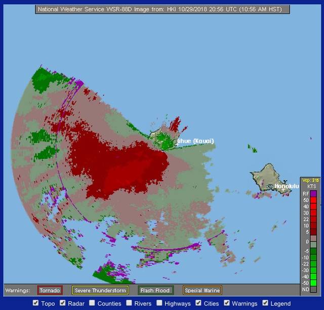
Just before noon on Monday, the NWS radar showed the island entering the jaws of a storm system with potential for heavy thunderstorms, wind gusts of up to 50 mph and a lot of rain.
“It’s out ahead of the area that we’re really concerned about,” said NWS forecaster Maureen Ballard.
Still coming is a trough to the southwest of the islands with a low front. That’s interacting with a front that’s approaching from the northwest and could mean some big storms — particularly on Kauai’s north and east sides.
“All these pieces are coming together over Kauai and Oahu,” Ballard said. “There are flooding possibilities, which Kauai has had quite a bit of this year already, and possibilities for landslides.”
The island is still recovering from storms in April and August that flooded areas on the North Shore and caused the closure of Kuhio Highway, west of Hanalei. That storm dropped more than four feet of rain on Hanalei and the North Shore in 24 hours from April 14-15.
Hurricane Lane passed by the state Aug. 22 through Aug. 28, dropping more rain and causing more flooding, though minor compared to April floods, through Kauai.
Monday, officials from the Hawaii Department of Transportation said work is ongoing to repair Kuhio Highway and restore it to a drivable condition. Slope wall installations at the road washout areas (mile markers 6.5 and 4.5) have been completed but the foot of slope revetments, paving, guardrail, and other finish work remains.
And while they’re working, HDOT crews are keeping an eye on the skies.
“We are in communication with the construction manager and have asked them to prepare for heavy rainfall,” said Shelly Kunishige, HDOT spokeswoman.
Those signed up for project updates are receiving messages as well, she said, regarding the Flash Flood Watch and a notification will be put out via social media and email should severe weather cause impacts to the work zone or make it unsafe to continue convoy operations.
“Tonight and tomorrow is the greatest threat,” Ballard said. “Damaging winds are possible and thunderstorms tonight and early tomorrow.”
Ground saturation is a potential, especially for the North Shore, and landslides are a potential.
“We’re still looking at a developing situation,” Ballard said. “Once it starts raining and if it gets heavy, stay put. Don’t go out. Hunker down and pay attention.”
See The Garden Island newspaper’s daily weather report on page 2.
•••
Jessica Else, environment reporter, can be reached at 245-0452 or at jelse@thegardenisland.com


