LIHUE — Ocean currents have a hand in hurricane activity, and studying the history of water circulation could lead to better forecasting, according to the U.S. Geological Survey.
To that end, experts cracked into the Earths’ history books to see how storm activity was influenced 13 thousand years ago, during the early Holocene period, and they’ve found a pattern.
Their research was recently published in the scientific journal, Geology, and it focuses on activity in the Atlantic Ocean.
But, a historic look at the Pacific Ocean’s patterns can lend perspective as well, according to Curt Storlazzi, with USGS’s Pacific Coastal Marine Science Center.
He says the El Nino Southern Oscillation (ENSO) has contributed to the way corals have formed around Hawaii, for instance, and a change in ENSO contributes to ocean conditions.
More recent records (about 10,000 years old) from Hawaii have shown that ENSO, at least around Hawaii, drastically ramped up in intensity around 5,000 years ago, resulting in larger North Pacific winter storm waves and larger Southern Ocean swell during the summer, according to Storlazzi.
“This caused most coral reefs in Hawaii, except those in sheltered areas, to shut down,” Storlazzi said.
And El Nino’s influence is worldwide, according to experts, because it is connected to currents and water temperature.
No El Nino conditions occurred this year, and that has factored into an increased number of storms in the Atlantic and a decrease in storm prevalence in the Pacific.
“El Niño suppresses (storm) development in the Atlantic, so certainly the lack of El Nino means you tend to get more activity (in the Atlantic),” said David Wroe, forecaster with NWS.
In May, because of a predicted weak El Nino, the NWS storm forecasters predicted eight storms to move through the Central Pacific in the 2017 season, which runs through Nov. 30.
So far, zero have entered the Central Pacific and as of Thursday, there was no storm activity in the Eastern Pacific, either.
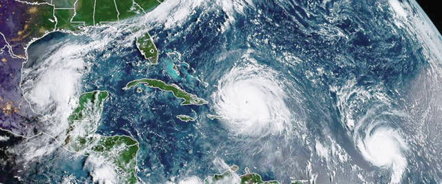
While ocean conditions and their influence on weather is known and documented, there has been a sharp increase in Atlantic Ocean activity. So far this season, eight hurricanes have formed in the Atlantic and there have been twice the number of hurricane days.
A hurricane day is calculated when a hurricane spins in a location for 24 hours somewhere in the Atlantic.
The latest storm, Tropical Storm Nate, was setting its sights on the Gulf of Mexico as of Thursday and is predicted to make landfall somewhere along the Gulf Coast Sunday.
All of the storm activity has prompted research further into Earth’s geologic past, in the early Holocene period, when environmental conditions were similar to that of today, according to researchers.
“This was a unique interval of geologic time, and gathering data from real events allows us to ground truth and refine models, which can ultimately lead to better forecasting of future hurricane activity,” said Michael Toomey, USGS scientist and lead author of the new report.
The new study focused on the influence of the Atlantic Meridional Overturning Circulation (AMOC) in the Holocene period, as well as the earlier Younger Dryas period.
Data showed that a dramatic reduction in AMOC triggered favorable environmental conditions for hurricane development near Florida thousands of years ago.
“This concept of using the Younger Dryas as a test for how storm activity might change in response to sustained AMOC slowdown hadn’t been explored before,” Toomey said. “Few currently published tropical cyclone records extend beyond the past few thousand years.”
Looking toward the future, researchers hope to look at whether increased hurricane activity thousands of years ago was widespread throughout the U.S. Eastern coastline, or focused on Florida.
Researchers analyzed sediment cores collected offshore from Florida in 2002 in order to develop the study.
The study can be found in the journal of Geology, Oct. 2017 in an article entitled “Increased hurricane frequency near Florida during Younger Dryas Atlantic Meridional Overturning Circulation slowdown”, authored by USGS, the Woods Hole Oceanographic Institution, Texas A&M University and the Bermuda Institute of Ocean Sciences.