KAPAA — Doug Haigh, county building division chief, will present “The Waipouli Connection of the Multi-use Path” 2 p.m. Saturday at the Kapaa Public Library. The event by the Wailua-Kapaa Neighborhood Association is free and open to the public. The
KAPAA — Doug Haigh, county building division chief, will present “The Waipouli Connection of the Multi-use Path” 2 p.m. Saturday at the Kapaa Public Library.
The event by the Wailua-Kapaa Neighborhood Association is free and open to the public.
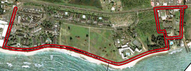
The Waipouli Path segment, formally known as the Lydgate Park-Kapaa Bike/Pedestrian Path, Phase C&D, is the 1.1-mile long section which will close the gap between the completed Wailua and Kapaa portions.
Haigh’s presentation will show the proposed route and the detailed “conceptual alignment plan” maps. He will also describe the regulatory process involved and the pending Special Management Area permit and Shoreline Setback Variance permit which are the final steps. A public hearing for these permit applications is scheduled for Sept. 12 before the County Planning Commission.
“For island residents, the ocean is a way of life and the largest buffer possible should be established between the coastal path and the shoreline,” said Rayne Regush, W-KNA Chairperson.
Starting at Papaloa Road, the route goes between Kauai Shores Hotel and Islander on the Beach. The path’s alignment will encompass the existing sidewalks within the county beach reserve along the Islander on the Beach, the Kauai Coast Resort Beachboy and the Marriott Courtyard Kauai. These sidewalks will be expanded on the makai side to create a 12-foot wide concrete path.
The presently undeveloped Coconut Beach Resort property, owned by SPD II Makaiwa Resort Development LLC, has been dropped from the county’s SMA Permit application with the brief explanation: “to be built by others.”
Beyond the Marriott Courtyard Kauai, the path goes through the undeveloped Coconut Plantation Village Resort. This parcel has a required 100-foot shoreline setback and a State Historic Preservation archaeological site, which consists of Native Hawaiian cultural deposits. The site has been designated as a preserve, but nevertheless, the county is seeking a variance permit.
The path then turns mauka at the Mokihana of Kauai and follows an existing county beach access. A pedestrian bridge is proposed to cross Uhelekawawa Canal on the makai side of Kuhio Highway to join with the sidewalk at Waipouli Beach Resort.
Although the county’s original intent was to locate the coastal path “as far mauka from the shoreline as possible,” now almost 95 percent is proposed to encroach into the shoreline setback area.
“With the permanent loss of traditional landscapes, the issue of being able to easily fish and gather on our coastlines without intrusion is important,” Regush said. “W-KNA prefers that the Path’s alignment be respectfully setback an appropriate distance, so as not to disturb those who are enjoying these activities in the natural environment.”
The Waipouli Path corridor is a tsunami inundation area, affected by storm waves, flooding and erosion. And, seasonal fluctuations such as tropical storms and King Tides have brought the high wash of the waves mauka of the certified shoreline in some places and reaching the proposed Path.
“It seems that county is minimizing the consequences of building the path too close to the shoreline. The cost to taxpayers will be paid by our children and grandchildren,” Regush said. “The coastal path is a wonderful legacy for the future, but only if it is placed in the best possible location along the coastline.”
Residents are encouraged to attend to learn about the path proposal and ask questions. A portion of the meeting will also feature Kauai Historical Society executive director, Helen Smith, with a brief talk about the innovative Kapaa Walking Tour app that is under development.


