LIHUE — A tropical storm watch was in effect for the islands of Hawaii, Maui, Molokai, Lanai and Kahoolawe on Saturday as strengthening Hurricane Ignacio approached the state.
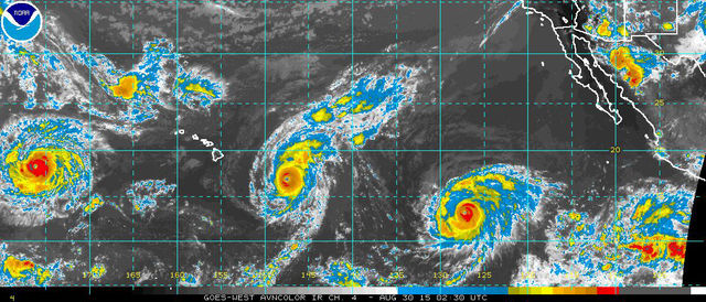
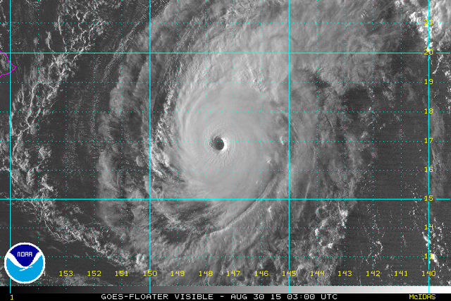
Ignacio built into a Category 4 hurricane with maximum sustained winds of 140 mph on Saturday afternoon, but was expected to weaken by Monday.
For Kauai, it was predicted to pass northeast of the Garden Isle between Tuesday and early Wednesday as a Category 1, with winds around 80 mph.
“We’re pretty confident in the track,” said Chevy Chevalier, meteorologist at the National Weather Service in Honolulu. “It’s supposed to weaken by the time it affects Kauai.”
That would mean wind and rain on Kauai, with possible flash floods if it sticks to the forecast path.
But Kauai is near the southern border of the hurricane’s cone of uncertainty, which is an expanded path along which the storm could travel should it shift in either direction.
If it followed the southernmost path in the cone, that could mean more severe weather for Kauai.
“But that’s not the current forecast track; it’s supposed to go further north of Kauai,” Chevalier said. “The problem, of course, is if it gets around the islands and shifts west, which is not unheard of, then it would make landfall and that’s what we don’t want.”
As of 5 p.m. Saturday, Ignacio — the 9th named storm in the Eastern Pacific this season — was 840 miles east-southeast of Lihue.
Chevalier said it’s important for people not to compare current hurricane watches to what’s happened in the past.
The state monitored Kilo’s path last week, which missed the islands after getting plenty of focus.
“Forget the history of it, the rest of them, where they turned and the rest of it,” he said. “Watch this one.”
Hurricane Ignacio is moving northwest at 9 mph. It was expected to weaken beginning today, although the state could begin to feel the impacts as early as this evening.
Gov. David Ige signed an emergency proclamation anticipating the storm Friday.
Swells generated by Ignacio along east- and southeast-facing shores of the Big Island will increase to 15 to 20 feet today through Monday, creating potentially life-threatening surf conditions, forecasters said.
The NWS said on its website that people should not focus on the exact forecast track. Forecast, movement, direction and speed are only estimates and even small errors in the track can mean major differences where the worst conditions will occur.
“For the rest of the island, I say, get ready, watch the forecast, listen to those announcements because they tell you not to focus on this exact tract because they could change, but be prepared,” Chevalier said.
Category 4 Hurricane Jimena was behind Ignacio Saturday but still far away. It wasn’t expected to cross into the Central Pacific Region until Wednesday.
By Thursday, it was expected to weaken to a Category 2, where it could be around 900 miles east- southeast of Lihue — where Ignacio was Saturday.
“It’s a concern, but for now it’s kind of a side-burner concern with Ignacio,” Chevalier said.
Kilo was also a Category 4 storm Saturday, but was far to the west of the islands near the International Dateline.
Hurricane Kilo defied model forecasts last week and intensified. It has been an active tropical system for 10 days now, but poses no threat to land.
Kilo may continue to gather strength over the next several days as it curls northwest, forecasters said.
If Kilo crosses the International Dateline, it would be renamed Typhoon Kilo.
Kilo is the fourth named storm to have formed in the Central Pacific basin this season and the sixth to track through the basin this year, including Eastern Pacific storms Guillermo and Hilda.
Loke became the record-breaking fifth storm to form this season in the Central Pacific Friday, according to Eric Blake, hurricane specialist at the National Hurricane Center.