LIHUE — Tropical depression Kilo is no longer projected to hit Kauai, nor will it grow to hurricane strength, Meteorologist Chevy Chevalie said Monday. “It’s very unlikely given where it is on the current track,” said Chevalie, of the National
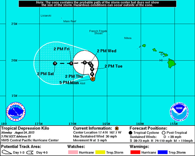
LIHUE — Tropical depression Kilo is no longer projected to hit Kauai, nor will it grow to hurricane strength, Meteorologist Chevy Chevalie said Monday.
“It’s very unlikely given where it is on the current track,” said Chevalie, of the National Weather Service’s Central Pacific Hurricane Center.
As of 5 p.m. Monday, Kilo was centered approximately 595 miles south- southwest of Lihue, drifting slowly to the northwest. The system is now forecast to make a sharp swing nearly due west by Wednesday, taking it away from the islands.
The swing is almost exactly opposite of the movement that had originally been projected, but the cyclone was never able to strengthen to a hurricane as expected.
“Everything seems to show that it’s going to densify, but for some reason it just doesn’t,” Chevalie said. But “we do still expect it to strengthen to tropical storm status.”
A tropical depression is upgraded to a tropical storm once it has sustained winds of 39 mph, and becomes a hurricane when wind speeds hit 74 mph. Kilo did briefly develop into a tropical storm, but then it weakened back into a tropical depression.
“The thing that will tear apart a hurricane are colder sea surface temperatures and wind shear. Those are the things that will… make it lose its energy,” Chevalie said. “We have the warmer temperatures and the weak shear – that is normally when we see intensification. But (Kilo) hasn’t been able to get organized.”
With the island no longer in danger of getting hit, heavy rain is the biggest threat.
“That’s our primary concern right now,” Chevalie said.
Residents and visitors should take precautions against danger from flash floods, lightning, heat and humidity.
“It’s pretty rare to get lightning here, but it can happen with all this moisture in place and the heat,” Chevalie said, advising people to head inside when lightning is happening.
Chevalie said heavy rain should ease off by Wednesday, and the normal trade-wind pattern should return by the weekend or early part of next week.
Chevalie also warned island residents and visitors to not drive over water covered roads.
“The biggest killer for flash floods is when people are driving in their car, Chevalie said.
The island is currently under a flash flood warning until 6 p.m. today although that could be extended.
Despite the fact Kilo missed Kauai, its effect is still being felt.
Preliminary reports show that during the 24 hour period from 11 a.m. Sunday to 11 a.m. Monday, more than 5.6 inches of rain fell in Kapahi and more than 3 inches fell at the Lihue Airport. More than 2.5 inches fell in Poipu and nearly 2 inches fell in Princeville.
Kilo’s passage also created unusually muggy weather.
Damaris Estrella complained about the humidity on Monday.
“I’ve lived here for three years and yesterday we bought an air conditioner for the first time,” Estrella said. “It’s just miserable.”
With warmer surface waters given the storms lots of energy, the Central Pacific Hurricane Center is expecting an active hurricane season.
w On Thursday, U.S. Senator Brian Schatz announced that Hawaii will receive $495,943 from the federal government for tsunami preparedness.
Schatz, who serves on the Senate Appropriations Committee, said that the funds will be used for preparedness activities such as inundation mapping, disaster planning, and tsunami education.
The funds will be administered by the Hawaii Emergency Management Agency.


