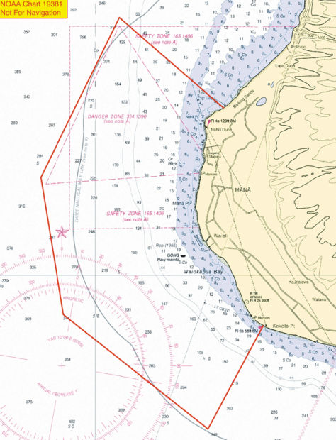
LIHUE — The U.S. Army Corps of Engineers has approved the Navy’s request for an expanded danger zone in the waters fronting the Pacific Missile Range Facility.
The decision comes months after the proposal drew fire from local residents during a public comment period ending July 31.
Beginning Jan. 15, the zone will roughly triple in size, encompass about 7 miles of coastline — from Barking Sands to Kokole Point — and extend between 2.96 and 4.19 nautical miles out to sea.
In a release Tuesday, PMRF said the modification will ensure public safety as the base moves closer toward scheduled launches of microsatellites next year from its new southern launch pad, part of the University of Hawaii and NASA’s Super Strypi project.
Navy officials stress the modified zone will only be enacted for launches as necessary and around affected areas, accommodates other future range operations and maintains continued public access as part of the Navy’s Range Safety and Access Initiative.
“We took this process very seriously and actively solicited and valued the inputs of our neighbors, with whom we share the beaches and waterways,” Capt. Bruce W. Hay, PMRF’s Commanding Officer, said in the release. “Public access to the beaches for swimming, fishing, surfing and other recreational activities will not be affected except during launches and training events, in line with current policy. To the general public and tour boat operators familiar with PMRF’s shoreline, the beach and water access is business as usual.”
Currently, PMRF’s danger zone is situated near the base’s northern launch pad.
The official notice amending the boundaries of the existing danger zone was posted in the Federal Register on Monday, following a 30-day public comment period and nearly six-month review process initiated in July.
“The amendment expands the boundaries of the existing danger zone to include an area necessary to protect the public from potential hazards associated with weapon systems testing, other military testing and training activities, and increased threat conditions,” the Corps wrote in its summary.
Historically, closures occur an average of 25 times per year — with each one lasting between 30 minutes and a few hours, according to PMRF. The current danger zone has been in place since the late 1960s, but missile launches have not been conducted from the southern end of the facility for about 30 years.
Any partial closures in the danger zone will be indicated by a Notice to Mariners, the presence of PMRF range boats, beach markings, including beach signs along the north and south beach borders alerting shoreline foot traffic, security patrols and radio transmissions on common ocean frequencies to include Marine band channel 6 (156.300 Mhz), Marine band channel 16 (156.800 Mhz), and CB channel 22.
In addition, the danger zone closure schedule will be posted on the PMRF official website and Facebook page. The danger zone closure schedule may also be obtained by calling (808) 335-4301 or (808) 335-4388.
As of Tuesday, no closures had been scheduled.
The PMRF proposal was introduced two months after the Hawaii Army National Guard announced a separate but similar proposal for an expanded danger zone in the waters surrounding the Kekaha Rifle Range. The Guard later withdrew the proposal, citing a mistake by a project manager.


