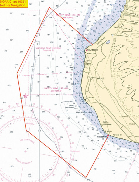
LIHUE — Two months after the Hawaii Army National Guard announced and later withdrew its proposal for an expanded danger zone in the waters fronting the shooting range in Kekaha, the U.S. Navy has followed suit.
On Monday, a public notice was posted by the U.S. Army Corps of Engineers outlining a separate but similar plan for the area surrounding the Pacific Missile Range Facility.
“Ours has been in the works since last September,” said PMRF Public Affairs Officer Stefan Alford, who added that the proposal by the Guard is “totally unrelated.”
If approved, the danger zone fronting PMRF would roughly triple in size, encompass about 7 miles of coastline — from Barking Sands to Kokole Point — and extend between 2.96 and 4.19 nautical miles out to sea.
“Currently, PMRF’s danger zone is situated near the north launch pads, but the modification is necessary to include planned launches from a southern pad as part of the University of Hawaii and NASA’s Super Strypi project,” states a release.
The Super Strypi, or SPARK (Space-borne Payload Assist Rocket — Kauai), is a new rocket design capable of carrying small satellites into orbit at a low cost, according to parabolicarc.com.
“They’re still constructing the launch pad right now,” said Alford, adding that the initial launch will likely happen early next year.
Alford added that when a launch is scheduled at the southern end of PMRF, the northern end would remain open — and vice versa — so as not to restrict access to the entire coast.
To accommodate future range operations, ensure safety and guarantee continued public access to its shoreline, the Navy developed a Range Safety and Access Initiative (RSAI), consisting of a written policy that formalizes the existing rules for beach access, according to the release.
“Public access to the beaches for swimming, fishing, surfing, etc., will not be affected except during launches and training events, in line with current policy,” PMRF Commander Capt. Nicholas Mongillo said in Monday’s release.
Historically, closures occur an average of 25 times per year with each one lasting between 30 minutes and a few hours, according to Mongillo.
“To the general public and tour boat operators familiar with PMRF’s shoreline, beach and water access is business as usual,” he said.
The current danger zone has been in place since the late 1960s, but missile launches have not been conducted from the southern end of the facility for about 30 years, according to Alford.
Under the RSAI, the proposed danger zone would be closed to the public during range operations, test and training activities and force protection conditions that are determined to pose a hazard to the general public, states the release.
“We understand the public’s right to access,” Alford said.
Various levels of public access to the beaches and water areas along PMRF’s 7-mile coastline have existed for decades. Following the terrorist attacks of Sept. 11, 2001, most civilian beach access was restricted. But, in 2005, PMRF introduced the Morale, Welfare and Recreation Guest Card Program, which allows card-holding civilians to access the area through the main gate and travel to Majors Bay recreation area and Shenanigans beach restaurant.
In August 2012, PMRF further relaxed beach access along its north and south boundaries to facilitate walk-in civilian beach use, according to the release.
“MWR guest card holders will continue to enjoy Main Gate access, 365 days per year, unless heightened FPCON (force protection conditions) is in effect,” Mongillo said. “North and south beach boundary walk-in access is expected to exceed 300 days per year. PMRF estimates that the only times north and south boundary walk-in beach access will be restricted, or limited, is during heightened FPCON levels, during hazardous range operations, or to protect endangered species.”
The Corps notes the proposal would have “practically no economic impact on the public, no anticipated navigational hazard and no interference with existing waterborne traffic,” as stated in the release.
Public comments on the proposal can be submitted through July 31. For more information www.regulations.gov, docket number 2013-15669.
In early May, the National Guard proposed to intermittently restrict public access to a larger, six-mile wide area of ocean fronting the Kekaha Rifle Range during live target practice. The Guard later withdrew its proposal following a series of articles published in The Garden Island.
Lt. Col. Charles Anthony, director of public affairs for the Hawaii National Guard, said at the time that the expanded danger zone proposal was the result of a “mistake” made by a project manager.
“(It) was developed based on an overabundance of caution to ensure public safety, but would encompass an area larger than is required by federal regulation,” he said.
The Guard is expected resubmit its proposal for a smaller danger zone.
• Chris D’Angelo, environment writer, can be reached at 245-0441 or cdangelo@thegardenisland.com.


