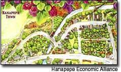
A town. self-to guided map is now available educate and inform visitors and residents of the history of Hanapepe Buildings along the 1.5-mile route are shown in perspective, with emphasis on use and heritage, according to leaders with the Hanapepe
A town. self-to guided map is now available educate and inform visitors and residents of the history of Hanapepe
Buildings along the 1.5-mile route are shown in perspective, with emphasis on use and heritage, according to leaders with the Hanapepe Economic Alliance.
Residents and business owners worked with leaders of the Hanapepe Economic Alliance to research the history, and have designed a full-color, Historic Hanapepe Walking Tour map.
The research and design of the Historic Hanapepe Walking Tour map was funded as a three-year project by officials at the Hawaii Tourism Authority and in the County of Kaua‘i Office of Economic Development. Several public meetings were held in 2004 as outreach to Hanapepe businesses and residents old and new. The result of much input created the map available now. Hanapepe has 43 buildings and sites that meet the criteria for listing on federal and state registries of historic places. A goal of the project is to increase appreciation for town heritage and the people who built Hanapepe, according to leaders of the Hanapepe Economic Alliance.
Over the next two years of this project, Hanapepe Economic Alliance leaders plan to introduce this map and related curriculum to children in schools, and invite young people to learn the history and heritage of Hanapepe.
Historic Hanapepe Walking Tour maps are being delivered to all Hanapepe stores. Hanapepe residents and businesses will work with HEA leaders to improve and promote this project together.
A marketing campaign is underway, with coupons to promote this map.
The suggested price of the map is $2, to encourage visitors to value the map as a souvenir. A goal is to distribute 5,000 during the next six months.


