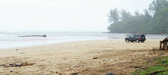
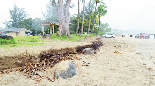
HANALEI — A wall of tangled roots separates the park at Black Pot from the beach, and the erosion has drastically changed the beach from six months ago.
While geologists say shifting sands aren’t unusual, it’s a prediction of what could be coming in the next few decades and scientists say long-term studies of the area are necessary.
“Right now the beach appears to be recovering from an erosion event that started in late August/early September,” said Ruby Pap, Coastal Land Use extension agent with Hawaii Sea Grant.
She said it was probably due to elevated water levels, high tides and north swells.
Other areas of Hanalei experienced erosion as well, including Waikoko on the other side of the bay.
The County of Kauai received photos of the exposed roots and severe erosion in September, which prompted county staff to trim the ironwood trees fronting the shoreline and place boulders along the vehicular access, blocking cars from the area.
Three months later, the beach has changed so much that the boulders are no longer doing their job. The line between the beach and the grass has become a three or four-foot drop, and large pieces of driftwood are caught in the exposed roots.
The cause is still a mystery in many ways, but researchers say discharge from the Hanalei River and seasonally large waves most likely play their part.
“Both periodic large ocean waves and high discharge river flood events can erode both rivermouth sandbar deposits and coastal beach deposits and move the sand offshore, in this case into Hanalei Bay,” said Kauai geoscientist, Chuck Blay.
He continued: “A coincidental combination of both events could have caused the movement of the Hanalei Rivermouth sandbar bayward.”
And bayward it has been pushed — with all of the sand that used to be on the beach causing shallower nearshore waters that extend into the bay.
“The water is shallower because the sand that was formerly on the beach has eroded offshore,” Pap said.
It’s not the first time the park at Black Pot has bumped shoulders with the beach. According to the Kauai Shoreline Study Erosion Maps, the beach was eroded up to the lawn at the beach park in the 1960s. There are typical erosion episodes and then periods of recovery.
“This area of shoreline is very dynamic due to the influence from the Hanalei River on sand movement, in addition to waves and tides,” Pap said.
Blay said the Hanalei River floods frequently, especially during the winter months, and that such high river discharge floods move the rivermouth sandbar around.
“We also know that large, highly variable ocean waves, especially during winter months, can narrow a beach by grabbing the sand and taking it offshore,” Blay said.
The geoscientist has been studying sand movements around Kauai for years, and said the story of shifting sands plays out all around the island, with different results depending upon existing conditions.
“Just the right combination of river and wave process could have caused the recent, apparently abnormal erosion of Black Pot Beach,” he said.
And while these natural processes are playing out an age-old story, the section of coastline that houses Black Pot Beach has a historical erosion rate of about a foot per year, according to the shoreline study.
At the same time the shorelines are crumbling at Black Pot Beach, the Hawaii Climate Change Mitigation and Adaptation Commission released its first Hawaii Sea Level Rise Vulnerability and Adaptation Report. The document combines scientific analysis of seal level rise vulnerability with recommended best practices for the future.
Predictions within the document point to a sea level rise of more than three feet by the year 2010 and the more extreme predictions pointing to reaching that number by 2060.
That kind of sea level rise would chronically flood about 6,500 structures statewide and cost around $19 million just in losses from chronic flooding of land and structures in the sea level rise exposure area. Nearly 38 miles of coast roads are predicted to be be affected, as well as 550 cultural sites. More than 13 miles of beaches are predicted to be underwater as a result.
That highlights the importance of long-term studies at places like Black Pot Beach, scientists say.
“It’s important to monitor our beaches closely so we can better understand their patterns,” Pap said. “Sea level rise from global climate change is likely to increase erosion significantly and we may be seeing some of that impact already.”


why waste time on studies. its a part of the earths cycle. this island has changed over the years. deal with it and do the best you can.
aloha
The unusua and extensive erosion at Blackpot Beach appeared during a confluence of currents, east and west, scouring the sand and revealing not only tree roots but a line of rocks and concrete pilings put there by man. The County has elected to leave this “armoring” in place. The Blackpot Beach and Park will experience the continued impacts of this decision as well as the compaction of sand caused by vehicular use of the beach. The County was given management of this beach by The State and is clearly abdicating this responsibiliy by not removing the armoring and allowing the natural processes to occur. The public asset is at stake. Save Backpot Beach!
After H’cane Iniki , the County had large boulders put in behind the Kapaa Neighborhood Center to stop erosion, and it appears to have been very effective with no apparent advancing erosion since then, yet before the hurricane erosion was taking its toll and was much worse as a result of the hurricane.
Though man cannot stop changes to sea level, unless of course pollution of every flavor causing warming and polar melt is the issue; or God thinks we need more sea water to dilute the ocean pollution.
A question: the article says prediction is sea level rise by 3’ by year 2010…bfut we have passed 2010 and has the sea risen 3’ already? When was the base sea level measurement taken to say the sea level rise has been 3’ by 2010; and what is the 2060 measurement that is hinted at?
Seems there has been a typo or 2 in the article.
Mahalo
Charles
It is unnecessary to inject CAGW in every story regarding the sea shore and erosion. Not only is it pure speculation, but it detracts and sometimes excuses dealing with the real cause. In the instant case, this area is far larger now than it was when I was a child. The river has also changed dramatically. It used to have defined banks and was easily accessible from all points along the road. Its course was closer to Princeville .
As a navigable river and important recreational site….. the mismanagement and neglect is criminal!
The County did NOT trim the ironwood trees fronting the beach.
The County chopped them down completely. As in clear cut.
Big difference.